
Back to...
Magazine Index or
Home Page
(Click on images for a larger version in a new window.)
Following cycle trips in the previous two years, both of which ended on the
Isles of Orkney, my new found love of the Scottish Islands had grown, and this year I planned
to ride the "Outer Hebrides" or the "Western Isles" as they are also 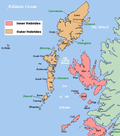 known. They lie on the extreme North West of Scotland and are the last land between
us and the North American continent. Battered year after year by wind and waves
from the vast Atlantic they have a rich history, culture, and more Golden Eagles than I have
seen anywhere else in Scotland. Altogether an exciting destination.
24th September: I had just arrived by train at Glasgow Central on a wet and windy afternoon. Standing in the station with my bike, I felt very much a fraud. The last time I was in Glasgow (2005) I had already cycled around 600 miles from Land's End, and here I was, fresh from a reasonably comfortable night in the Euston Hostel and straight off a train. I had found last year's ride even harder than the E2E, so I planned to take a gentler pace this year, and this was just the beginning.
Unreported in Mutters, my 2006 ride had been planned and executed as a follow
on from the E2E and although I did not want to do the same distances again, I still wanted
it to be a challenge and I had chosen what I hoped would be a good route through Scotland
and back to the Orkneys.
It started at Hull on 20th September and took me up the bleak and dismal north-east coast
of England to Newcastle; north of which, the scenery and my enjoyment of the ride both improved
dramatically. Staying close to the coast and using hostels whenever possible, I
headed North and into Scotland following the Firth of Forth into Edinburgh, and then west
passing the Grampian Mountains and the Cairngorms National Park.
I followed the A86 down Glen Spean to Fort William and on to the west coast Ferry Port of
Mallaig where the Sky ferry took me over to Armadale for a ride up the East coast and a night
at Broadford before crossing the Kyle of Lochalsh next morning to start the journey up the
coast of Scotland to Durness.
From Durness it was a one (heavy) day ride across the north coast with plenty of highs and
lows, passing Bettyhill where the Highland Clearances are commemorated, passing the charismatically
named Dounreay Nuclear Power Plant that I remembered being in the news so much in the 60's,
arriving at Scrabster with only minutes to spare for the ferry to Stromness on Orkney.
My trip was plagued by foul weather and if it was hills I had wanted, then I had chosen the
route exceptionally well. Overall I suffered a little too much for my liking and
vowed to go easier next year.
Well, the next year had come and with little adaptation, I was taking the
same Giant hybrid I had bought and kitted out for the E2E in 2005 with the Ortlieb Back Roller
Classic panniers (which I have raved about before) and the dreaded handlebar bag by Altura
which I have had to concede is a "must have" for any lengthy days alone in the saddle. An
electronic mapping wheel replaced the old mechanical one and I had a couple of new bits of
technical clothing to provide those necessary extra layers when needed.
I had been told repeatedly that the weather in the Hebrides can be foul, temperamental, and
at times lethal with sudden sea mists descending to chill and disorientate you. Having
left Essex at the end of a particularly poor summer, I expected the worst. Because
of these warnings I had bought a survival bag (a tin foil sack that you actually get into
like a turkey if caught out, and one of those hand warmer things you light and shut the lid
on). Better safe than sorry!
In fact, whilst the south had a prolonged period of heavy rain and cold, I basked in sunshine
in the far north Atlantic and, despite some cloudy days, had only a half day's rain and little
wind. It couldn't have been better; but according to locals - I was lucky.
My plan was to cycle from the most southerly inhabited island of the Outer Hebrides, Vatersay,
up to the most north-westerly point, the Butt of Lewis (Shouldn't the Butt be at the bottom?),
experiencing the island culture and scenery on the way. I had read that some parts
were very remote with only the occasional shops and fewer bars, that Gaelic was still the
main language for many and that in some communities, travelling on the Sabbath was not acceptable. It
was going to be interesting.
As always, I intended to stay in hostels and there are plenty to choose from on the islands
including some very basic crofters' cottages I had read about, owned and run by The Gatliff
Trust (www.gatliff.org.uk). In
1961 a London businessman named Herbert Gatliff, who was a supporter and Founder Member of
the Youth Hostel Movement, decided that there should be hostels on the Outer Hebrides, which
he had visited and loved.
He believed hostels should be "simple places where you can cook a meal, dry clothes and enjoy
the company of like minded travellers". He set up a trust fund and a body to manage
it which today owns four "rustic" hostels, each of them in remote and tranquil locations by
the shores near Howmore (South Uist) Balle (Berneray), Rhenigidale (Harris) and Garennin (Lewis). In
keeping with the Founder's original ideals, they provide basic accommodation where a traveller
can cook, wash and sleep for around £10 per night at today's prices. I had already
decided that I would try to stay at all four of these hostels, both for the experience and
as a further challenge for the trip.
25th September: My route from Glasgow took me to Chrianlarich with
the gentle but long six-mile climb from the Drovers Inn to the youth hostel. The
hostel was filled with climbers and walkers it seemed as mine was the only bike in the shed.
26th September: The morning was cold and bright and some of the climbers
were saying there was fresh snow on the tops, but I couldn't see any myself, just the thin
rain that was starting to fall.
I had cycled this part of the route in 2005 so knew roughly what to expect. I headed
off down by Strath Fillan crossing rivers and burns; looking at each for one of my favourite
birds, the Dipper (Cinclus cinclus) and if lucky watch their antics as they walk under the
water in search of food.
The first port of call was Tyndrum, with its famous Green Welly Stop, from where my route
branched onto the A85 into Glen Lochy and along Loch Awe to "Hollow Mountain". This
is an incredible Hydro Generating Project built in the 1960s, which is almost wholly buried
in man made caverns 1km deep inside Ben Cruachan, it uses surplus night time electricity to
pump millions of gallons of water from Loch Awe up to a mountain reservoir then, on demand,
releases it back down to the loch providing instant peak time power (www.visitcruachan.co.uk).
The Pass of Brander is built out over the Loch and heads west to Loch Etive and eventually
the Falls of Lora, a wide estuary area where the shallow waters create a two directional sea
waterfall at the foot of the climb up Ben Derloch. From the top of the climb it
is straight down to sea level and into Oban, the "Gateway to the Hebrides". I stayed
overnight at the Oban Youth Hostel as the next ferry would not leave until 3pm next day arriving
on Barra, the most southerly port, at around 11pm. The Hostel is an imposing Victorian
house built on the promenade just a short walk from town with a Common Room overlooking the
Harbour and Sound providing wonderful views. I rode out to find the ferry terminal.
I bought my ticket in readiness for the next day then returned to the Hostel to cook and enjoy
some lively company which included three really nice, but very loud Glaswegians. All
special needs and completely unintelligible (remember Rab C Nesbitt?), they were up for one
of their regular 'holidays' and determined to enjoy every minute.
27th September: After breakfast over a spectacular sunrise, I had
time to spare. I cycled to the nearby Dunolie Beach and did some exploring around
Oban. The town is dominated by a Victorian Folly which resembles the Coliseum,
which a local entrepreneur had commissioned simply to provide work for the local stonemasons
who were otherwise redundant. It has never been used or completed and looks down
over the town as a constant reminder of harder times (and wealthier individuals).
There are the usual shops, bars and hotels, some nice-looking restaurants and the quay has
some terrific seafood stalls cooking and serving locally caught produce - something I had
missed in Scotland up till then as everything caught there seems to be destined for somewhere
else with no sign of a cockle stall or fishmonger anywhere on the coast or the islands.
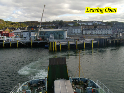
I arrived early at the terminal and with a coffee in hand waited on the quayside until the
ferry was ready for boarding and I was called forward. I walked the bike down onto
deck, secured it to the side, and within minutes was on the Observation Deck as the "Lord
of the Isles" slipped away from Oban and the Scottish mainland.
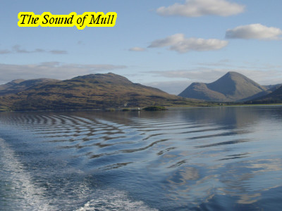
The ferry sailed out past Mull then headed into more open water passing various Inner Hebridean
islands to the north including Muck, Eigg, Rum and finally tiny Canna.
Coll and Tiree passed almost unnoticed to the south like ghosts but brought back vivid memories
of my parents listening to the Shipping Forecasts when BBC radio was our nightly entertainment.
Porpoise (or dolphins - no one seemed sure which) were spotted in ones and twos and later
in larger groups as well as rafts of sea birds such as Guillemots (Uria aalge & Cepphus grylle)
and Eider (Somateria mollissima). The Crew said to look out for whale or basking
shark but none appeared.
The stillness of the evening was stunning, there was hardly a ripple on the sea and the sun
beamed down.The islands slipped away in our wake and eventually we were told we could now
see the Outer Hebrides appearing on the horizon. Quite exciting at the time. The
sun was dipping below the silhouetted Island of Barra sending the sky blood red whilst on
the starboard side a full moon was rising into a clear sky.
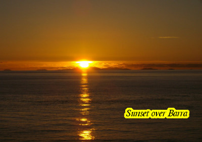
The conditions were the best the crew had seen for years and even they were in awe. The
ferry docked first at South Uist (about a third of the way up the Islands) and, once unloaded
and reloaded, moved on to reach Castle Bay on Barra half an hour or so before Midnight.
The terminal is a single slipway and on walking off, it was easy to see the individual houses
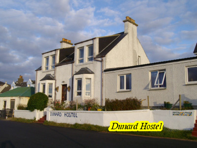
fronting the Bay where my first stopover would be. The Dunard Independent Hostel
was one of the closest to the jetty and I soon found my name entered on the "Bed Board" telling
me my room number and that I would be sharing with 2 others. It took little time
to unload the bags, store the bike and shower before bed. I had arrived, and tomorrow
I would head South on to Vatersay to the most southerly point of the Outer Hebrides before
starting North for The Butt of Lewis.
September 28: My first day in the Outer Hebrides dawned bright and
sunny. The very name, "The Outer Hebrides", excited me; a name I had known of since
childhood, as I listened with my parents to the BBC Home Service Shipping Forecasts. I've
no idea why as we had nothing to do with the sea but we always listened anyway.
I set out from the hostel, crossing a causeway which had only been built about 10 years ago,
and cycled onto Vatersay, the most southerly of the inhabited Isles. It was from
the south end of this island that I planned to start my ride and it did not take long to reach.
On my way back I stopped at an idyllic sandy cove called South Bay, where I found a memorial
stone dedicated to 350 Souls who were shipwrecked there on the 28th September 1893. I
had arrived on the exact day, 114 years after the wrecking of the "Emma Jane" out of Liverpool
and bound for Quebec carrying 450 crew and emigrants heading to a new life. What
tragedy. The memorial stated that their bodies lay close to that spot but I suspected
that many were never recovered.

Cycling back over the causeway I turned west onto the coast road which goes right around Barra
forming a complete circle. To the north it passes Cockle Bay, a huge flat beach
which is used as a landing strip at low tide. It's the only beach in the UK used
for commercial flights and British Airways fly scheduled flights to and from the mainland
providing a much needed link for the Islanders. I continued on my clockwise route
and down the eastern coast road passing over the lower reaches of Mount Sheabhal and back
into Castle Bay for a pint and a read in the sun before returning to the Hostel.
September 29: Set out at 8:30 to return to the north coast, avoiding
Mount Sheabhal this time, to catch the 10:00 ferry to Eriskay. The sun was still
shining and I was amazed at how tranquil it was. The Crossing was short and, as
is always the case, there was a stiff climb up from the small harbour. The first
thing I saw was a colourful shrine to "Our Lady", inside a white picket fence. A
hand painted sign declared "Ave Maria". The landscape was bleak and rocky with
only small scattered settlements along easy rolling roads over this small island.
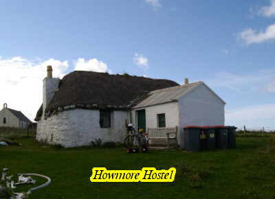
On the north shore a causeway took me across to South Uist, which is about 23 miles long. I
was heading about half way to a place called Tobha Mor where a lane to the coast would take
me to the "Howmore Hostel" an old crofters cottage owned and run by the Gatliff Trust.
Not far from Toba Mor I stopped by the roadside for some lunch and was sitting on a boulder,
close to the bike, when a lorry passed too close and blew it over. The handlebar
turned 180 degrees and the brakes wedged firmly under the frame. By unhooking the
brake arms I could get the handlebars back the right way but one of the brake pads had broken
in two. Given the total absence of bike shops so far (or any shops for that matter),
I realised I may have to complete the rest of the journey with rear brake only - not a pleasant
thought knowing the mountainous sections to come. Alternatively, I could change
plans and head for the capital of Stornaway for repairs. I'd sleep on it and decide
tomorrow.
I headed off a little worried by developments and could not believe my luck when about half
a mile on I saw a bungalow advertising "Bike Sales and Repairs". Other than in
Stornaway near the end of my ride, it was the only bike repairers I saw on the Islands. Someone
was definitely looking out for me. £3.50 and a little work saw me back on the road
with a full set of brakes and a huge smile.
I arrived at Howmore not quite knowing what to expect of these "Basic Hostels" and found an
old thatched building, dry stone built with walls two feet thick and a similar building but
with a corrugated roof. Both contained dorms, somewhat dank, with metal bunk beds,
sparse furniture and toilet facilities. The larger of the two contained a kitchen
and common room with dining table and coal burner. As the first to arrive I chose
a bunk close to the common room, cleaned up and sat outside to admire the views with a mug
of tea and my flute. The hostel overlooks the ruins of an ancient chapel and graveyard
where amongst others, the remains of several chiefs of the Clan Ranald are reputed to lie.
Eventually, 5 more people showed up to stay the night. In order of arrival these
were Indra (cyclist), Arron (motor cyclist) Gavin & Alison (cyclists) and John (walker with
car). Indra, Arron and I were to go on to stay together at all 4 Gatliff Trust
Hostels and John 2 of the 4. Together we shared food and drink and some memorable
evenings around the various log or peat stoves.
Being the first night, we were a bit unsure of each other, but as the evening wore on we found
that we got along pretty well. The fire was lit, lit and relit, but due to a blocked
flue, that the warden cleared later, the common room and kitchen were smoked out for several
hours. No one seemed to care and Indra and I took it in turns trying to blow the
fire into life. Several of us cooked and food, wine and beer were shared. Later,
Indra produced a bottle of 10 year old single malt whisky that she had lovingly carried from
Cambridge (coals to Newcastle?) This was generously shared each evening, and carefully
rationed to ensure it lasted out her trip. (Bless!)
September 30: We had discussed routes last night and both Indra and
Arron were also heading straight to the second of the Gatliff Trust hostels, on the island
of Berneray. John would stay an extra day and go off walking before following on. Nothing
was decided about riding together but Indra and I were fairly evenly paced and we were soon
heading north together.
We continued north along flat roads passing lochs, lakes and river inlets, crossing over the
causeway to Benbecula at around 11am. It was Sunday and we had been warned that
if we could find a shop, it would close by mid-day for certain, and probably be shut all day. We
toured the small villages we passed but found only one tiny shop and post office which as
feared, was closed. I normally ensure that I have some basics in my panniers, enough
to provide a meal or two if caught out, but so early in the ride, I had not stocked up and
once my packed lunch was gone, finding some food would be important. Surplus food
left by other hostellers can sometimes provide a meal, but you never know until you arrive!
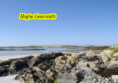
Crossing over yet another causeway we arrived on North Uist where the road forked to the west
or the east. Indra had heard that the western coast road was the more scenic (and
hilly) so we agreed to go west and make for the beach at Hogha Gearraidh for lunch. It
was sunny and warm and I took half an hour to comb the beach and do some bird watching.
After lunch we headed up on to the north coast and watched the clock continuously as we had
heard there was a shop on Berneray that may be open till 5. The last leg of the
day, as always, was quite tiring, the road seemed to get ever longer and the climbs harder. We
eventually reached the final causeway for the day just after 5pm, so any hope of a shop was
forgotten. Berneray is a tiny island, just 3 miles by 2, that was formerly a Monastic
settlement and the hostel is right on the beach on the far side.
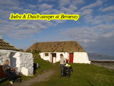
On passing through the only village, I saw a local woman coming to her gate and asked her
if there was anywhere to buy some food. She shook her head then asked what it was
we needed. I said we could really use some pasta. She went indoors
and returned with a pack of spaghetti and would not take anything in return. Saved!
With pasta and what we had to pool later, we would feed the 3 of us and another traveller
who arrived hungry.
Arron had arrived already and was talking with a Dutchman who was wild camping on the shore
(but with the comforts of the hostel close by). A quick a cup of tea and then Indra
(a committed swimmer who should be committed!) decided this was her best chance of a swim
in the sea. Arron and I decided to try it too. (Idiots!) To say it was
cold is a total understatement. One quick swim and I was out - leaving Indra and
Arron to certain hypothermia. As it was I lost all feeling in my feet for about
half an hour and standing on concrete felt like standing on wet sponge. A very
weird sensation.
October 1: The next Island in the chain was Harris and there was an
early ferry crossing to Levenburgh at about 7am. Indra was the only one taking
it as she wanted to reach the next Gatliff Hostel at Rhenigidale in one day. Arron
and I took the lay in and the 11am ferry instead. I had plenty of time and intended
to take an extra stop en-route. It was cold and grey but as the ferry docked,
the sun was trying to shine and eventually broke through for a beautiful afternoon. It
was back to solo riding for me which I have always enjoyed but it was still good to see Arron
two or three times in the day as he whizzed around on his motor cycle.
Harris is the only mountainous island in the Outer Hebrides and as such it seems out of place.
It also, reputedly, has the best beaches and as I followed the west coast I was soon passing
wide bays with miles of golden sands and coral blue waters. The Island of Taransay,
lies just off this coast which was used as the backdrop for the 2000 TV series "Castaway".
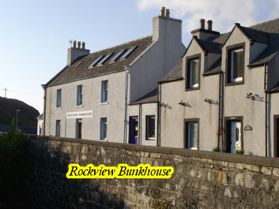
My destination was Tarbert, a Ferry Port on the north east coast from where I would eventually
leave the islands. I wanted to stay at The Rockview Bunkhouse, an independent hostel
overlooking the harbour and next to a Fish and Chip shop (which only opened for about an hour
a day), as well as a pub. Who could ask for anything more!
But first there was the small matter of the central mountain range to cross. The
road from the coast was not severe but climbed and climbed up to a dizzy height with peaks
on either side. The road was deserted with only a few sheep here and there grazing
on the rough grass and heather which covered the slopes. There were amazing views
of the sea lochs, Loch a Siar, looking back to the west and Loch an Tairbeart to the east. Once
up on the crest the road gently rolls and winds for some miles before descending steeply into
Tarbert and seamlessly crossed from South Harris to North Harris.
I could see the Rock View Bunkhouse as I sped down into the harbour but it was deserted and
a sign on the door directed callers to the post office. The Post Mistress is also
the Warden of the hostel and she gave me the punch key code to get in for the night.
There are two local stores so I took this chance to stock up on some fresh supplies, as, for
the next couple of days I would probably not see any shops. Adding weight to the
bike is always a concern and it is surprising how much the basics for a few days weigh - especially
the wine and beer.
I had the hostel to myself at first and after the usual preparations and clean up, enjoyed
a fish and chip supper accompanied by some local beer while watching the evening ferry to
Skye load and depart. Gavin and Alison, from the Howmore Hostel arrived about 7pm
and headed off to a local restaurant for a posh nosh. This was as far as they were
going and would be heading back south tomorrow. A walk around the town and another
beer in the pub this time and I was ready for bed.
October 2: My goal for today was Rhenigidale, the third of the Gatliff
Hostels and one of the most remote. At the height of the final range of mountains
that separate Harris from Lewis, a road snakes off to the right and literally drops down to
a river valley floor before a 1:4 climb and an equal descent to the tiny village of Rhenigidale.
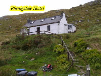
When I say village… there is no pub or bar, no shop, no church or police. Just
a few cottages, a public phone, one street lamp and a small stone cove. It was
the UKs most isolated community until 1990 when the EU funded a road to connect it to the
highway. Up until then it was only accessible by sea or by walking over the cliff
path to Tarbert - about 10 miles - which, for many decades, the school children did each day. Even
the National Grid did not reach here until 1980.
My ride today was only about 20 miles allowing me to leave late and take a relaxed pace over
the various climbs to arrive at Rhenigidale early afternoon. The last mile or two
lived up to the warnings and by the time I arrived, despite my preference for solo riding,
I was pleased to see Indra's bike by the hostel.
The hostel is back from the bay and sits at the top of a steep incline up a lot of steps.
Indra had stayed over for a second night and was busy cleaning the hostel top to bottom (it's
strange how quickly a hostel becomes home, especially if you are alone) She showed me around
and I chose the best bunk available. It is a lovely tranquil hostel with a really
good common room and coal fire, but as with most hostels money is tight and I had to carry
out some repairs to the bunk bed before I could use it. Indra went walking so my
time was my own again. I cut some wood and lit the stove, made tea and set about
my flute for an hour before getting the maps out once again and poring over routes and distances.
A German walker dropped in for a drink and when Indra returned we all chatted over more tea.
Arron was next to show up followed later by John and with each new arrival more was added
to the communal larder for the night. I cooked a wild mushroom ragout for us all
which we ate with soda bread whilst sitting round the fire cooking some excellent sausages
(John's I think) on top of the burner. There was enough wine and beer for the three
of us (plus a tot of Indra's malt whisky).
Late in the evening, in the pitch black darkness outside, a middle-aged man
appeared on the doorstep asking if this was the hostel as he wanted to stay the night with
his wife. He seemed a bit strange and out of place, but it's a hostel so we told
him there were spare bunks and that his wife would be in with Indra and he with us. That
was not good enough and after some debate Indra agreed to move so he and his wife could stay
together. Then he said about the dog! We did not think it was right in a hostel
but with no warden here, we guessed it would be OK if the dog could sleep downstairs. Oh
No! "He had to sleep with them". We agreed again. He brought his wife
in, a very nervous looking oriental woman, with mongrel dog in tow, and Indra took them up
to see the dorm. The final straw was when they insisted the dog be allowed to sleep
on one of the bunks. That was enough and Indra told them firmly it was "Not On". They
scurried back down and headed to their car without another word. It was the last
we saw of them but we locked the door anyway. Very strange!
October 3: That would be the last night that all four of us stayed
together as John had decided to go his own way from here. It was sad saying farewell
to him in the morning and we each took photos and exchanged e-mail addresses. John
was first to leave and waved as he headed up the steep rise away from the small bay to walk
to Tarbert.
The fourth and last Gatliff hostel was Gearrannan. I left Rhenigidale just after
John, wanting to get the stiff climbs out of the way at my own (snail) pace. I
regained the high main road and sat looking back at this rugged and remote landscape before
moving on and down from the mountains. After a final 4 mile long descent I was
heading north again on the much flatter roads of Lewis.
It was grey and cold on the road and later, the only rain that I saw on the Islands fell in
misty sheets which were not enough even to wet us through. Indra had caught up
to me late morning (I spent the rest of the day trying to keep up with her) and just before
turning off of the main road to head west again we found a garage with a small shop and restocked
the saddle bags and ate lunch while calling home.
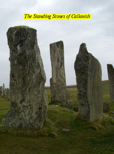
The Standing Stones of Callanish were a welcome diversion. They are about 10 miles
short of Gearrannan and have a modern visitor centre and café. We viewed the stones
which are megalithic, then spent a while in the centre warming up before heading along the
rocky coast road to Carlabhagh, where a small lane leads to the Black Village.
The hostel is one of 9 preserved Crofters cottages forming the Black Village. It's
a wonderful hostel which has been sympathetically restored and is as cosy as they come. There
has been a settlement here for over 2000 years and the current Black Village, so called for
the colour the thatches turn after weathering, dates back to the 17th Century. This
isolated crofter community grew potatoes, oats and barley, grazed sheep and cattle and took
their fuel from the moorland. On the very edge of the coast in a sheltered bay,
the sea provided another harvest and an income from Herring Fishing was to be made. They
wove to provide their own cloth but the "Harris Tweed" was renowned and generated a new industry.
Two world wars, difficulties in maintaining local employment and the natural desire of the
young to broaden their horizons and embrace the new world, saw the traditional way of life
falter and it barely survived beyond the 1950's. The older Crofters remained through
what must have been desperately hard times until at last, in 1974, the last residents moved
to new homes, provided nearby by the Island Council.
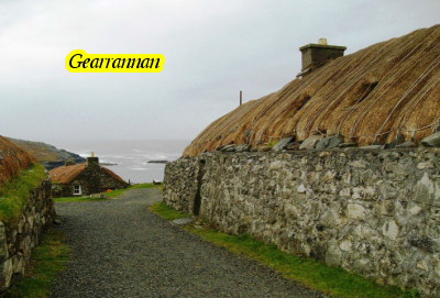
Fortunately for us, The Gearrannan Trust (www.gearrannan.com)
was formed and this amazing place is preserved. The Cottages now form self catering
accommodation and there is a museum, a visitor centre and the hostel. The museum
deserves special note as it is one of the Crofters' homes, set out just as it would have been
in 1950. It must be seen if you visit there, and of especial interest for us were
the re-cycling (forgive the pun) of a Crank and Cog set as a movable cooking plate over the
peat fire; and a whole bike converted to a Spinning Wheel.
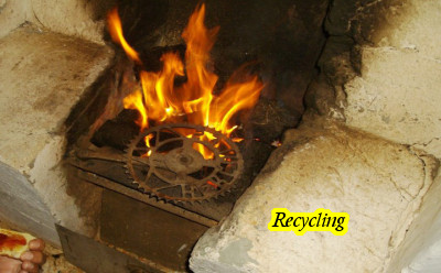
October 4: I decided to spend a second night before heading north to the Butt of Lewis. It was incredibly sad as first Arron, then Indra made their way away from me and I was left alone in the now deserted village. I relaxed in the hostel for the morning, played the flute, read, and pored over maps before heading out along the cliffs to watch the birds. A golden eagle hunted really close and perched on rocks giving me excellent views. Finally, back at the hostel I cooked for myself, drank a glass of whisky that Indra had kindly left for me, and slept.
October 5: I was missing my companions more than I could have expected.
Each of my annual rides to date had been completed in blissful isolation with not one mile
ridden with another person. That was what I was used to and wanted. But
the days spent together had had an effect and it took me a long time to get comfortable with
just my own company again. I felt very lonely and far from home. As
the others continued south and off of the islands, I said my goodbyes to Gearrannan, turned
left at the end of the lane and headed north.
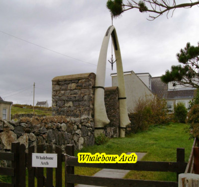
After some distance I passed a cottage with an enormous pair of whale bones forming an arch
over a gateway. It was called (not surprisingly) Whalebone Arch. A
harpoon hung in the centre of the arch and I later found out that the bones were from a blue
whale wounded and washed up on a local beach in 1920. The harpoon had penetrated
but the explosive head had not gone off. The Crofter who dealt with the whale and
the harpoon was fortunate to survive as the head later exploded in his shed. The
bones and the harpoon remain as proof of this remarkable tale.
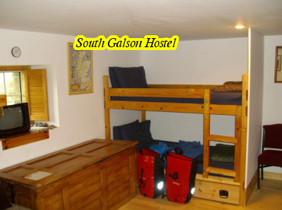
I would be staying at the most northerly Bunkhouse on the Hebrides. South Galson
is about 10 miles or so from the Butt of Lewis. I checked in and dropped my baggage
before heading on as there was a strong SW tailwind which had helped so far, but I knew the
return leg to the hostel would be harder. It's a small family run hostel with just
a six bunk dorm, shower room and small kitchen, but it is recently refurbished, well equipped
and friendly. I was the only person checking in as far as the owner knew so I chose
my bunk, had a quick tea and a sandwich, and headed off again.
Running up the west coast of the most northerly island was exciting, if the road itself was
a bit boring. It was a wide open landscape and the road dipped and rose again and
again, passing tiny hamlets or crossing wide open moorland with coastal views in between. Port
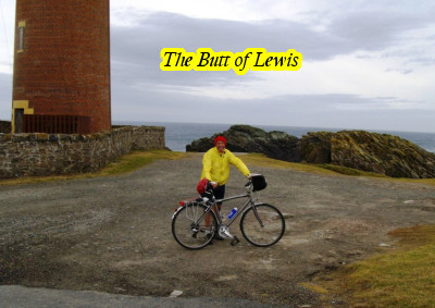
Nils is the most northerly village, sitting right on the north edge of the islands. From
here a track headed out to the Butt of Lewis, and the finish line of my Hebridean End to End.
It was magnificent at the Butt with strong winds driving huge waves onto the massive lumps
of rock which form the headland. Spume was flying high into the sky as sea birds
wheeled and screamed around. I took some time to sit and recover, take a few photos
and reflect on my journey to this point. Then, ever conscious of the time, I turned
around and headed back to the hostel.
The ride back was as hard as I had expected. The landscape offered no protection
from the wind which was now almost gale force and all I could do was to keep my head low,
drop the gears and keep going (with one stop for a celebratory whisky! In what was just recognisable
as a "bar") until finally the sign for the hostel was there and I was able to turn out of
the wind and down the farm track to park up for the night.
Another cyclist had arrived while I had been out and amazingly we recognised each other. Andy
and I had shared a room two years ago in Browns Hostel on Orkney. What a small
world!
October 6: The morning was grey, the wind still blowing strong from
the south east, and I still had a fair way to go to get back. Today would take
me across Lewis to Stornaway for one night, then on to Tarbert for another and a ferry to
Skye where I would meet with some friends up on holiday, spend a few days exploring and a
couple relaxing at the brilliant Waterside Inn and Bunk House at Carbost, (almost next door
to the Talisker Distillery). From there, via the beautiful Cuillin Mountains to
reach the ferry to the mainland for the "Jacobite Steam Train" featured in the Harry Potter
films from Mallaig to Fort William; a train from Fort William to Glasgow Queens (both spectacular
train rides) for a last night in the Scottish Youth Hostel and a morning train back south
to London and home.
This was my 3rd annual solo ride since retiring, and each year, there are times that I wonder
"What on earth am I doing here." It is not always easy or enjoyable and at times
it can be really lonely. I miss my wife and my home (and my dog and my local). I
hate it if I have to resort to a B&B or anywhere too cold at night, and get sick and tired
of unpacking and repacking. But there is something that keeps drawing me back
to it. Something to do with being totally alone. Just me, the bike,
the panniers stuffed with all my gear, and an idea of where I want to be by the end of each
day, but no idea of what to expect.
It's great when the evenings spent poring over maps and hostel guides all work out; or not
as the case may be. When for no other reason than it's what I want to do, I change
my plans or my route and follow a different course. It's pure freedom.
When I retired I realised I had never actually been alone for longer than a day or two since
I was born. That amazed me and I reckoned I'd earned the right to do so now. Thanks
to my wife's understanding nature, for which she has my undying gratitude, (and possibly a
secret desire for some peace and quiet herself) I'm doing it!
The goals I had set myself this year had been achieved, my expedition was nearly complete,
but there was always next year to think of……… and the Shetlands sound interesting!